Gaussian Splatting for AEC: A Reality Capture Field Guide
Learn where Gaussian splatting fits in AEC reality capture, from recurring site documentation and remote review to BIM context and stakeholder tours.

Learn where Gaussian splatting fits in AEC reality capture, from recurring site documentation and remote review to BIM context and stakeholder tours.
Gaussian splatting gives AEC teams a fast, photorealistic way to revisit site conditions. Use it for visual context and stakeholder communication while survey control, BIM authority, inspection, and contractual records remain in their professional systems.
Short answer
Gaussian splatting for AEC is useful when a project team needs a fast, navigable visual record of a real place. Phone video, 360 footage, drone imagery, photos, laser scans, drawings, and BIM can each contribute different kinds of evidence. Gaussian splats are the photorealistic viewing layer: they help people understand appearance, depth, access, and spatial relationships in a browser.
Survey-grade measurement and engineering decisions still require controlled geometric workflows. AEC Magazine's industry review describes the same boundary while documenting growing use of splats for rapid site documentation and communication.
Spatial Studio is worth considering when the job is to turn supported capture media into a guided review experience. It can generate Gaussian splats, set an opening view, add named stops and hotspots, combine map or supporting-media context, publish a browser link, embed the result, and review engagement. Keep formal measurements, issue ownership, approvals, and record status in the authoritative AEC systems built for them.
Where Gaussian splats fit in the AEC stack
The term reality capture covers several jobs. Start with the decision, then choose the evidence.
| Project need | Useful capture or system | Appropriate output |
|---|---|---|
| Weekly visual progress | Repeatable phone or 360 route | Dated walkthrough with stable zone names |
| Remote owner update | Gaussian splat, panoramas, drone context | Guided browser tour with a clear review order |
| High-confidence measurement | Survey, laser scan, controlled photogrammetry | Registered technical dataset with documented tolerances |
| Design-to-site coordination | BIM, drawings, point clouds, issue platform | Aligned comparison tied to an owned issue |
| Exterior and logistics context | Drone imagery, map, site plan | Overview of access, staging, facade, roof, and surroundings |
| Handover or public communication | Curated spatial tour and supporting media | Stable, reviewed link with a clear audience and next action |
Autodesk Platform Services has demonstrated 3D Gaussian splats rendered with a BIM model in its web viewer. That is a useful signal about direction, but it does not make every image-only splat metrically reliable. Registration, coordinate systems, source control, and downstream validation still determine what a project team can safely do with the result.
What splats do well
Gaussian splats can preserve visual qualities that are awkward for a conventional mesh: foliage, thin elements, clutter, reflections, and view-dependent appearance. Continuous movement can also make a space easier to read than a folder of disconnected photos.
That makes them useful for:
- fast site familiarization before a review call;
- remote walkthroughs for owners and non-technical stakeholders;
- visual progress records when capture can be repeated safely;
- access, facade, roof, landscape, and logistics context;
- explaining where an RFI, finish, service, or constraint sits in the wider space;
- presentation alongside BIM, survey, point-cloud, or project-control data.
A splat can explain context while another system remains authoritative for dimensions, compliance, scope, and approval.
Start with cadence and route ownership
Teams often evaluate hardware before deciding how the record will be maintained. A modest capture repeated well is usually more useful than an elaborate capture nobody owns.
Assign one role to the route. Define the zones, safe walking path, camera height, naming convention, capture date, upload deadline, and first reviewer. Record weather, lighting, access restrictions, and work activity when they affect what can be seen.
A recurring route should:
- start from the same orientation point;
- use stable level and zone names;
- cover transitions, services, and access, not only finished rooms;
- include site, facade, roof, or logistics context where relevant;
- preserve each dated edition instead of overwriting it;
- flag omissions while recapture is still possible.
The Construction Progress Tour Guide turns that operating rhythm into a repeatable field workflow.
Turn capture into a review experience
A raw viewer asks every stakeholder to find the important condition independently. A guided review establishes orientation and then takes them to the places that matter.
Use the opening view to answer, "Where am I?" Add stops for levels, zones, elevations, or work packages. Put concise context in hotspots and link out to the owned RFI, drawing, report, or decision record when the viewer needs more detail. Use a map or aerial view when room-by-room navigation hides the scale of the site.
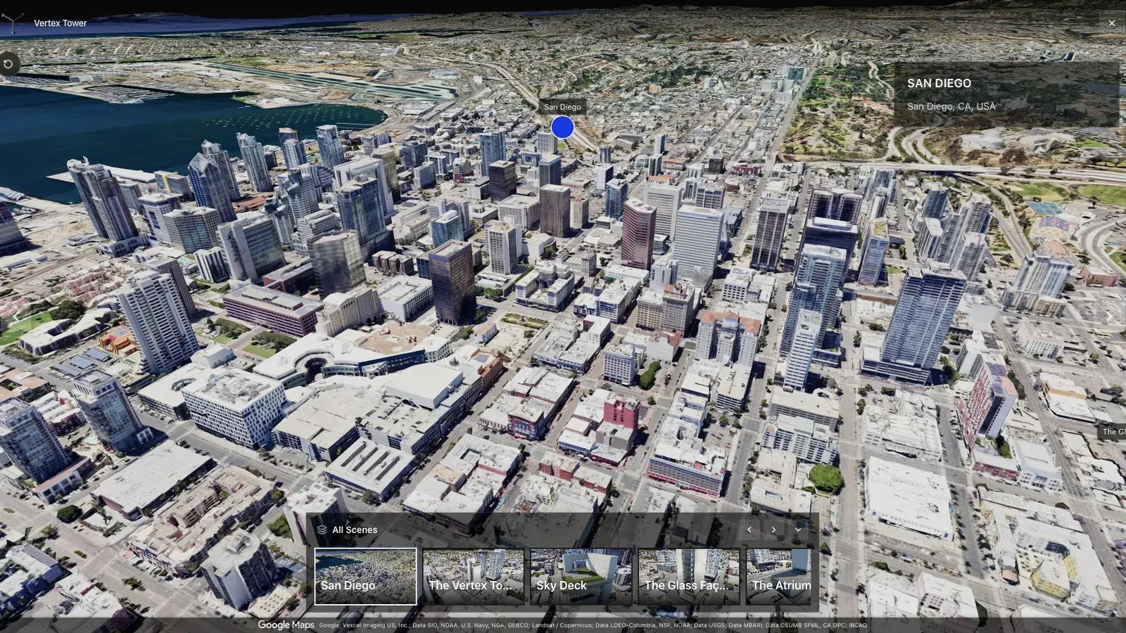
Open Vertex Tower, a fictional public Spatial Studio map example. It demonstrates browser navigation and site orientation; it is not a construction record or accuracy case study.
For recurring reviews, keep the same stop names and opening logic across dates. A reviewer should not have to relearn navigation every week.
Keep BIM, issue, and record authority explicit
BIM and drawing context is valuable when it reduces ambiguity between intended and observed conditions. The comparison does not need to be visually elaborate. It needs to help the team answer a specific question and then preserve the formal response in the correct system.
Use a simple responsibility split:
- survey and scanning workflows own measured geometry and tolerances;
- BIM and document systems own design intent and approved information;
- issue systems own assignment, status, and decision history;
- the guided spatial tour explains visual context and review order;
- project records preserve the formal outcome.
Avoid placing the only copy of an instruction, approval, or finding inside a tour hotspot. The link may change, the tour may be replaced, and the viewer is not the contract record.
A practical 90-day pilot
Start with one active project and one recurring coordination question.
| Phase | Action | What to observe |
|---|---|---|
| Weeks 1 to 2 | Choose a pilot area, route, cadence, owner, and review audience | Captures arrive consistently and cover the same zones |
| Weeks 3 to 6 | Add named stops, linked context, and a standard review sequence | Reviewers can locate the relevant condition without a guided screen share |
| Weeks 7 to 10 | Add drone, scan, BIM, or drawing context only where it helps a live decision | The extra layer resolves a specific ambiguity |
| Weeks 11 to 12 | Document the workflow and decide whether to extend it | A second team can repeat the process without inventing it again |
Track capture completion, time spent locating visual context, unanswered questions, repeat visits requested, and whether the intended stakeholders open the shared review. Do not turn avoided visits or faster calls into a marketing claim until the pilot records them consistently.
Common failure modes
- Capturing a different route each week and calling the result comparable.
- Publishing an impressive scene without named zones or a review order.
- Mixing internal issue evidence with a public owner or marketing tour.
- Treating a visually convincing model as accurate enough for measurement.
- Collecting more media than the team can label, review, and retain.
- Sharing links without an owner, audience, retention rule, or record status.
- Testing only on the workstation used to build the tour.
Frequently asked questions
What is Gaussian splatting for AEC?
It is the use of 3D Gaussian splat reconstructions in architecture, engineering, and construction workflows. The practical use today is photorealistic visual context for documentation, walkthroughs, progress communication, remote review, and presentation alongside technical project data.
Is Gaussian splatting the same as reality capture?
Gaussian splatting is one representation within a broader reality capture stack. Reality capture can also include photos, video, panoramas, photogrammetry, laser scans, SLAM point clouds, survey control, and measured models.
Can a Gaussian splat replace a laser scan or site survey?
No. Use a controlled scanning or surveying workflow when a decision depends on traceable measurement, tolerance, compliance, fabrication, or contractual evidence.
Can Gaussian splatting be used for construction progress?
Yes, for dated visual context, guided review, and revisiting site conditions. The capture route, naming, access controls, and record status must be consistent if the sequence is meant to support comparison.
Where does Spatial Studio fit?
Spatial Studio fits the capture-to-presentation path: supported media can become a Gaussian splat, guided tour, hosted link, or embed with viewpoints, hotspots, maps, supporting media, calls to action, and analytics. It does not replace the measured, compliance, estimating, or project-control systems an AEC team relies on.
Next step
Choose one site question that currently requires repeated explanation. Capture one safe, repeatable route, build a guided review in Spatial Studio, and test the public or controlled link on a phone and a desktop used by someone outside the capture team.
Continue with Gaussian Splatting for Construction Progress, review Gaussian Splat Hosting, or compare the wider Gaussian Splatting Software category before choosing the delivery stack.
Next step
Open the related workflow.
Review live examples or move straight into the matching Spatial Studio flow.
Continue reading
Related articles
Commercial Use Cases
Gaussian Splatting for Construction Progress: 360 Video and Splats
Use Gaussian splatting and 360 video for repeatable construction progress tours, remote site review, dated visual context, and stakeholder updates.
Read articleCommercial Use Cases
3D Property Damage Documentation for Insurance and Restoration
Plan 3D property damage documentation for insurance and restoration using photos, 360 capture, Gaussian splats, guided review, and clear evidence boundaries.
Read article